Enregistrez gratuitement cette image
en 800 pixels pour usage maquette
(click droit, Enregistrer l'image sous...)
|
|
Réf : T02168
Thème :
Terre vue de l'espace - Fleuves - Rivières - Lacs (517 images)
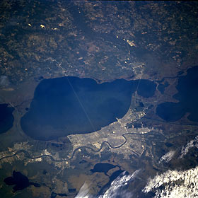
Titre : Southeast Louisiana, U.S.A. October 1995
Description : (La description de cette image n'existe qu'en anglais)
The low-oblique, north-looking photograph features greater New Orleans and areas north of Lake Pontchartrain in southeastern Louisiana. Discernible are urban New Orleans and several of its suburbs; the 24-mile (39-kilometer) causeway that connects New Orleans with Covington and other communities on the north shore of Lake Pontchartrain; the meandering Mississippi River; dark, linear canals; and the short Interstate Highway 10 bridge that connects northeastern New Orleans with Slidell. Apparent are the dark Pearl River as it flows south, eventually emptying into Mississippi Sound, and parts of Lake Salvador and adjoining Lac des Allemands within the extensive marshlands south of New Orleans.
|
|

